

 Italiano
 English
 Deutsch
 Français

Cavo Beach
Municipality of Rio, Elba Island
Photos of Cavo Beach
What Cavo Beach is like
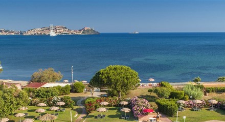
Cavo is the northernmost village on Elba's east coast, in the Rio municipality, facing the Piombino Channel. The village beach runs for about 420 metres from the harbour pier to the rocky headland topped by Villa Tonietti, and is sheltered by two breakwaters. The shore mixes fine sand and small light pebbles, and the fine-gravel seabed slopes gently. Opposite are the islet of Palmaiola and the Piombino coast.
Getting there
Cavo is also a ferry port: Toremar hydrofoils, for foot passengers only, dock at the pier next to the beach, arriving from Piombino after a crossing of about 20 minutes; some services continue to Portoferraio. By car you come from Rio Marina or Rio nell'Elba; the beach is at the village entrance, with parking nearby. In summer a municipal minibus links Cavo with the beaches along the coast as far as Ortano.
Which wind to go with
The best conditions come with the mezzogiorno (south wind), libeccio (south-west wind), ponente (west wind) and mistral. When the levante (east wind) or sirocco is blowing, it's better to head for the north coast, for example to Bagnaia, recommended in those winds.
Facilities and tips
A full-service village beach: beach clubs with umbrellas and loungers, free stretches, bars and restaurants, with shops and a pharmacy nearby. Canoes and kayaks can be rented, and there are sailing, water-skiing and diving schools. The village name comes from the Latin caput, meaning headland, and on nearby Capo Castello there are Roman remains: a short walk north takes you to Frugoso beach.
Beach factsheet
Where it is and how to reach it
Straight-line distances: the road route is longer.
Where to stay near Cavo Beach
Straight-line distances from the beach: properties are listed from the closest.